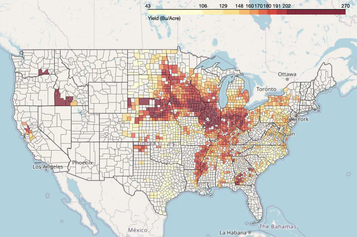
Sourav Bhadra
  • Bio
  • Blog
  • Experience
  • Projects
  • Publications
  • Recent & Upcoming Talks
    • Example Talk
  • Blog
    • Create powerful portfolio websites using Hugoblox
  • Publications
    • Spectral enhancement of PlanetScope using Sentinel-2 images to estimate soybean yield and seed composition
    • Drone-based imaging sensors, techniques, and applications in plant phenotyping for crop breeding: A comprehensive review
    • Hyperfidelis: A Software Toolkit to Empower Precision Agriculture with GeoAI
    • PROSAIL-Net: A transfer learning-based dual stream neural network to estimate leaf chlorophyll and leaf angle of crops from UAV hyperspectral images
    • End-to-end 3D CNN for plot-scale soybean yield prediction using multitemporal UAV-based RGB images
    • Soybean seed composition prediction from standing crops using PlanetScope satellite imagery and machine learning
    • UAV Multisensory Data Fusion and Multi-Task Deep Learning for High-Throughput Maize Phenotyping
    • Automatic Extraction of Solar and Sensor Imaging Geometry from UAV-borne Push-broom Hyperspectral Camera
    • An integrated machine learning and remote sensing approach for monitoring forest degradation due to Rohingya refugee influx in Bangladesh
    • Assessing the impacts of anthropogenic drainage structures on hydrologic connectivity using high-resolution digital elevation models
    • Data-Driven Artificial Intelligence for Calibration of Hyperspectral Big Data
    • A Fully Automated and Fast Approach for Canopy Cover Estimation Using Super High-Resolution Remote Sensing Imagery
    • Field-scale crop yield prediction using multi-temporal WorldView-3 and PlanetScope satellite data and deep learning
    • Early Detection of Plant Viral Disease Using Hyperspectral Imaging and Deep Learning
    • Quantifying Leaf Chlorophyll Concentration of Sorghum from Hyperspectral Data Using Derivative Calculus and Machine Learning
  • Projects
  • Experience
  • Projects
    • SustaiN
    • AgLapse
    • MapLapse
    • Raster4ML

AgLapse

Sep 16, 2022 · 1 min read
Go to Project Site

A spatiotemporal visualization tool for four major agricultural crops in the United States.

Last updated on Sep 16, 2022
Webapp Streamlit Mapping
Sourav Bhadra
Authors
Sourav Bhadra
Data Scientist

← SustaiN Jan 9, 2023
MapLapse Aug 28, 2022 →

© 2025 Sourav Bhadra.

Published with Hugo Blox Builder — the free, open source website builder that empowers creators.